|
Forgotten Housing Developments
And Other Brookline
Homes and Business Locations That Are Gone
When West Liberty Borough was formed in
1876, there was already a substantial number of homes, along with several
merchant establishments, located along West Liberty Avenue from Warrington
Avenue south to the borough line near upper Pioneer Avenue.
In the 1890s, when the Pittsburgh Coal
Company expanded their mining operations along the Saw Mill Run corridor, the
population of the borough began to increase at a rapid pace. Along Saw Mill Run,
several new housing developments first appeared on the maps.
The Boggs Place (Cadet, Lineal, Leavitt),
Zimmerman Park (Timberland), and Bailey and Moon (Abstract) plans sat along the
western hillside, running parallel to the West Side Belt Railroad tracks above
Saw Mill Run Creek.
Along the lower end of West Liberty Avenue,
plot maps from 1896 also show two new residential tracts between Cape May and
Pioneer. These were the C. Sauter and the Lewis/Garrigan plans. These small
clusters of homes were built at the base of the hillside. At the turn of
the century there were seven homes constructed in the Sauter development and
five in Lewis/Garrigan.

A 1916 map showing the C. Sauter and the Lewis/Garrigan
Housing Plans.
In 1940, the number of homes in
Lewis/Garrigan had risen to six. By that time, West Liberty Avenue had
evolved into more of a commercial roadway. The undeveloped plots in that
plan were occupied by the Manos Baking Company, a Tile and Mantel Outlet
and several smaller businesses.
As the years passed and the real estate
values along West Liberty began to rise, the homes in the Sauter and Lewis/Garrigan
plans were razed in favor of further commercial development. The Matthews Bronze
complex now stands in place of the seven homes in the Sauter Plan. Just to the
south, five individual businesses and the Dean Technical Institute occupy the
former Lewis/Garrigan property.
Below are some photos of the homes in
the long-forgotten C. Sauter and Lewis/Garrigan plans.
<><><><> <><><><>
<><><><> <><><><>
<><><><> <><><><>
C. Sauter Plan

A signpost along West Liberty Avenue
that reads "Sauter Place."
 
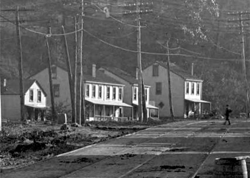
The homes of J. Vallor and J.A. Talbert
standing along West Liberty Avenue in March 1912 (left) and in October 1915.
When the street was widened to four lanes the front porches were removed to
accomodate the expanded roadway.

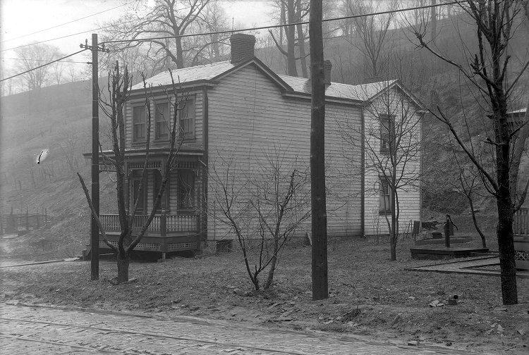
Three of the homes in the Sauter Plan,
standing at the base of the Pioneer Avenue hillside.
A view of the homes at the base of the
hillside on Sauter Place in 1915 (left) and in 1924.
<><><><> <><><><>
<><><><> <><><><>
<><><><> <><><><>
J.L. Lewis, J.E & M.P.
Garrigan's Plan

Looking south at the cluster of West
Liberty Avenue homes just north of Brookside Avenue in March 1915.
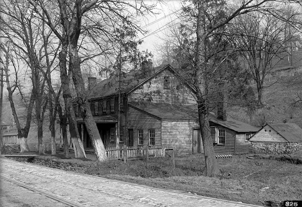
The homes of P. Parker and T. Beal standing
along West Liberty Avenue north of Brookside Avenue in 1912.

Looking north from the intersection of West
Liberty Avenue and Brookside Avenue in 1915.
Other West Liberty
Avenue Homes And Businesses
In Brookline That Are No Longer Standing
Along West Liberty Avenue, from Cape May
south to the city line at Stapleton Street, once stood several other neighborhood
residences and commercial establishments that have since been razed.
Where these vintage community structures
once stood, the hillside has been cut back in favor of additional commercial
development. The majority of these properties are now the site of autombile
dealerships and vehicle display lots.
Below are photos of several of these
long-forgotten Brookline buildings.
<><><><> <><><><>
<><><><> <><><><>
<><><><> <><><><>
Cape May Avenue To
Stetson Street
 
The American Mechanic Association Hall across
from Cape May Avenue (left) and a string of Brookline homes just north of
Stetson Street. The Mechanics Hall was built in the 1860s and was, until 1898,
the original West Liberty School.
It was also used as a church. The building was later the workshop of H.R. Bupp
Contractor and Builder.
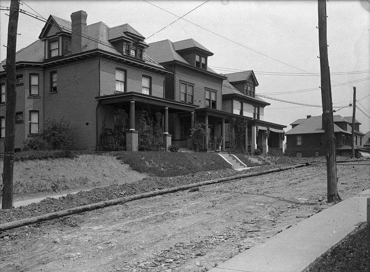
  Two views of Brookline homes between Cape
May Avenue and Stetson Street in March 1915. These homes were torn
Two views of Brookline homes between Cape
May Avenue and Stetson Street in March 1915. These homes were torn
down later that year during the reconstruction of West Liberty Avenue. Only two were replaced (shown below).

The recently constructed homes of J. Luffy
and F. Luffy, just north of Stetson Street, in June 1916.
<><><><> <><><><>
<><><><> <><><><>
<><><><> <><><><>
Stetson Street To
Ray Avenue

William G. Dooley's Central Meat Market
at the corner of Stetson and West Liberty Avenue in March 1912. Next to
Dooley's is the property of T. Harley, including a wood shed, home and a laundry
at the corner of Capital Avenue.

The laundry and residence owned by T. Harley
that stood at the Capital Avenue intersection, shown in June 1916.
A Pool Hall owned by Jacob Beltzhoover near
Capital Avenue (left) and the nearby home of George and Mary Beltzhoover.
During the West Liberty Borough days (1876-1907), this home was location of the
Fetterman District Post Office.
Mary Beltzhoover was the official West Liberty Borough postmistress.
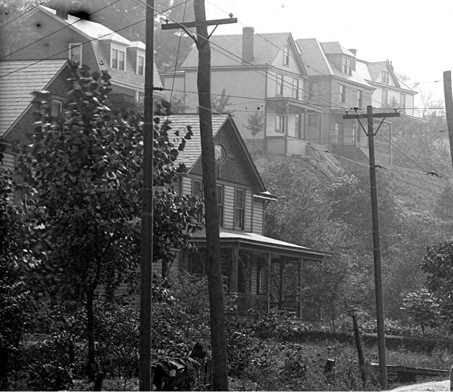
The homes of C.K. Boyd and J. Boyd, north of Ray
Avenue, in 1910. The houses along the hillside are on Fair Avenue.
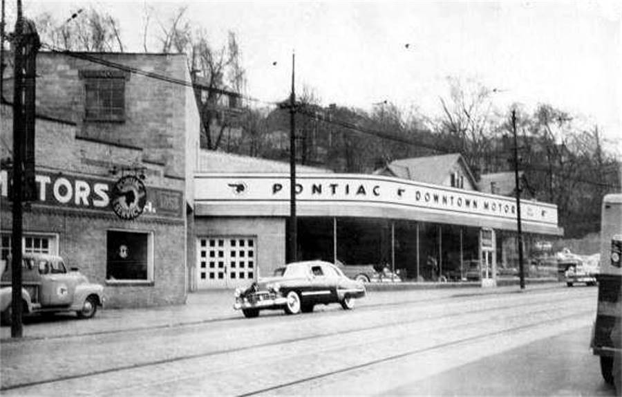

Downtown Motors, located between Capital Avenue
and Ray Avenue, was built in the 1930s north of the two Boyd homes.
The dealership building was expanded in the 1940s to include the land owned by the
South Hills Ice Company. The
Boyd homes were eventually razed to enlarge the parking and outdoor display area.
The dealership closed
in the 1980s and the building was torn down. Today it is the location of
a Toyota display lot.

A laundry owned by E. Cox, located just north
of Ray Avenue, shown here in March 1915. In the distance are the two Boyd
homes, and just beyond that, barely visible behind the trees, is the building that housed
the South Hills Ice Company.
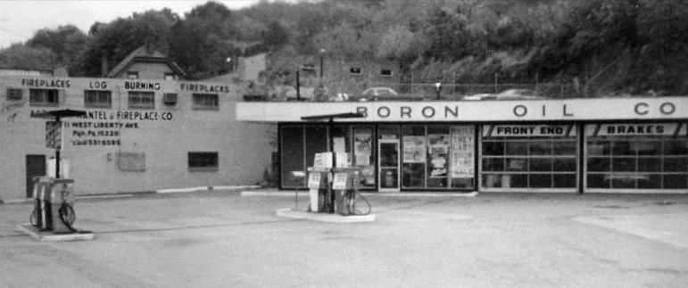
The Boron service station that stood at the corner
of Capital and West Liberty Avenue. It was built in 1960 on
the location of the old Harley laundry building, which by then housed a pizza
parlor. The Boron station
was eventually torn down and replaced by a BP gas station and convenient store.
Ray Avenue South To The City
Line
 
The left photo shows the homes of L.C. Kruckewill
and S.A. Harley atop the West Liberty Avenue hillside across from
Pauline Avenue. At street level is a home and grocery store owned by J. Claude.
Partially visible is another home
owned by the Harley family. To the right is the home of J. Harley. Both photos were
taken in March 1912.

The homes of E.M. Lehfuss and G.S. Monks that
stood just north of the Belle Isle Avenue intersection, shown in 1915.
Further north in the direction of Pauline Avenue are the Harley and Claude
homes.
 
The home of J.S. Armstrong on the corner of
Belle Isle and West Liberty Avenue (left), and a view of the Brookline
Junction, in March 1915. At the crossroads is the Pittsburgh Coal Company
power plant and air shaft.
Above the plant stands the old Knowlson Church, built in 1868, and the
estate home of A. Oyer.

Another view of the Knowlson Church and
the Oyer Estate in 1915.
 
The homes of M.S. Ammann, J.B. Smith and William
Underwood, just north of the city line, in 1912 (left),
and three homes owned by E.G. Burke in the Victoria Place Plan, between Stapleton
and Blaine Street.

A 1916 plot map showing homes along West Liberty
Avenue from the city line north towards the Brookline Junction.
Old Brookline Homes And
The Little Red Schoolhouse
 
The home of William J. Harley at 132 Brookline
Boulevard (Bodkin Street) in 1909 and the adjacent Harley Express
Moving and Hauling business. The white addition to the business structure is all that
is left standing today.

The David Hunter estate at the intersection of
Brookline Boulevard and Pioneer Avenue. The Hunter family
were prominent landowners in the West Liberty days. Bodkin Street was once known
as Hunter Avenue.
An apartment complex and Bellaire Avenue homes now stand on the former
Hunter property.
 
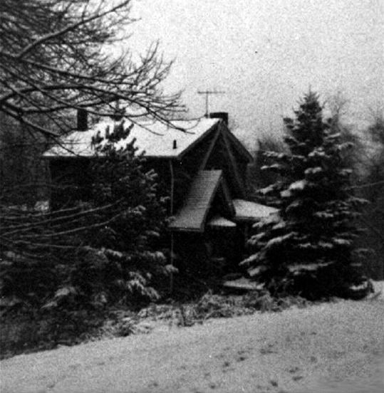
A home that once stood on the corner of Pioneer
Avenue and Brookline Boulevard, shown to the left in 1909. The house
was moved to the corner of Berkshire and Pioneer Avenue (right) in 1935. Also shown is the
small service station
that was built in it's place. Both stood until 1999, when razed during construction of the CVS Pharmacy.

The home that stood at the bottom of Whited Street,
along Saw Mill Run Creek, shown here in 1928.
The house was torn down in the 1940s. Today it is the site of the Jack
Maggs Agency.
In the photo to the left, the first two houses
at 1113 and 1115 Creedmoor Avenue, shown here in 1919, were
used as the home for the Sisters of Charity until 1956, when razed for the construction
of a new Convent.
The right photo shows the Greenawald home at 1136 Creedmoor Avenue, also shown in 1919.
It served
as additional housing for the Sisters from the mid-1940s to 1956, then as a priests
residence
until 1964. The building at 1136 Creedmoor was razed in 1965 during a school
expansion.

The home of O. Stanton at 409 Brookline Boulevard
(Bodkin Street), along the intersection with Pioneer Avenue,
shown in 1936. The home was eventually razed and an apartment building constructed
in its place.
  The Fleming estate, shown to the left in 1935, which
stood on the land that is now the site of St. Pius X Church.
The Fleming estate, shown to the left in 1935, which
stood on the land that is now the site of St. Pius X Church.
Elizabeth Fleming was the daughter of Richard Knowlson, who in the late-1800s operated
a 300-acre local farm.
To the right is the Oyer estate, shown in 1915 along West Liberty Avenue near the
Brookline Junction.

This grand home stood at the corner of Brookline
Boulevard and Wedgemere Avenue. Over the years it was the
location of a doctor and dentist's office. Before being razed in 1970, it
was the office of Dr. Kluber MD
and Dr. Hoover DDS. Today, this is the site of a Sunoco gas station and convenient
store.
 
The home of William Lang on the lower end
of Pioneer Avenue, shown to the left in 1924 near the present-day
intersection with Cadet Avenue, and the farmhouse of James Anderson, located along
Breining Street.
The Langs were influential West Liberty landowners. Pioneer Avenue was
once called Lang Avenue.
The former twenty-acre Anderson Farm is now the site of Brookline Memorial Park. The
farmhouse served as the Activities Building until destroyed by fire in 1971.

This is Elizabeth Seton High School on
Pioneer Avenue in 1970, shortly before the school was closed. The building,
called the Little Red Schoolhouse, was originally built in 1898 and expanded in
1906. Until 1939 it served
as West Liberty Elementary. Beginning in 1941, it was a Diocesan girl's high school.
The building
was razed in 1971 to make room for an expansion of the Elizabeth Seton Center.
Commercial Buildings Along
Brookline Boulevard

A customer pulling out of Ed Seebacher's Sunoco
service station, located at the Brookline Junction, in 1936.
 
The wood frame Freehold Real Estate office on
the Boulevard Triangle in 1910 (left), and a larger brick building in 1913.
The sales office stood until 1932 when Freehold closed it's Brookline branch. The
Triangle is now a memorial park.

The East Brookline Shopping Center at
Breining Street was a popular destination for those living in the 32nd Ward.
Shown here in the mid-1970s, there was the Coin-Op Laundry, Open Pantry Market
and Manco's Pharmacy.
The shopping center was razed in 1980 during construction of the Parkside Manor senior highrise.
 
A view of final few storefronts approaching the
Pioneer Avenue intersection, in 1936. Shown are Bisi's Market,
Shenkel's Bar and Brookline Pharmacy. These buildings were razed in 1999 to build the CVS Pharmacy.

The same buildings shown above, in early 1999,
prior to the start of the CVS Pharmacy construction.

The Mobil Gas Station at the corner of Glenarm
Avenue and Brookline Boulevard during the 1980 Halloween Parade.
The building was torn down in 1984 and a Stop-N-Go convenient store erected
in it's place. Today it is Co-Gos.
 
Buildings along the 900 block of Brookline Boulevard,
shown in 1933, that have since been torn down. To the left, the small
building with the Dry Cleaner and Market was destroyed by fire in 2004. The lot has been
vacant ever since. In the
picture to the right, the four smaller structures have been replaced by the Mazza Pavilion apartments.
The two in the center were destroyed by fire in 1973 and the other two were razed
in 1980.

The historic Reed Building at 1057 Brookline
Boulevard. Approaching 100 years
of age the building was purchased by Frank DeBor and demolished
to create additional parking for DeBor Funeral Home.
Brookline Car
Dealerships
 
Kilgore's Used Car Sales at 1545 West Liberty
Avenue (left), shown in 1945, and
Al D'Alessandro Cadillac at 2115 West Liberty Avenue, shown in 1955.
Downtown Pontiac at 2001 West Liberty Avenue,
shown in 1955.

Ralph Book Chevrolet at 2633 West Liberty Avenue,
shown in 1970.
Brookline Farms
The Anderson Farm, located between Breining
Street and the 1400 block of Brookline Boulevard, was owned and operated
by the family from 1874 to 1947. Shown here in 1936, the twenty acre
property is now Brookline Memorial Park.
The Subdivision Of
Brookdale
Brookdale was a
planned subdivision in Overbrook Borough. Maps as far back as 1916 show the layout
of the road network and property lots. In 1930 the land was added to the Brookline
census tract. Infrastructure and home construction began in the mid-1930s. By 1939,
there were six homes in the plan. Four were along Oakridge Street and two on
Daleview Street.
The key to the development plan was the
acquisition of the twenty-acre Anderson Farm, which stood between the
established developments to the west of the farm and the new subdivision
to the east. This land would have enabled connecting roadways into the
plan.

1940 plot map showing the homes in the Brookdale
subdivision.
To the dismay of the Brookdale Improvement
Company, the farm was eventually sold to the community in May 1947, with the
intention of creating a park. This left the Brookdale plan isolated, with only
one roadway (Briggs Street) leading into the housing development. From this point
on, only one new home was built in Brookdale.
In 1970, all but one of the seven
homes were sold to the Housing Authority and used as rental property. The only
house that remained in the hands of the original owner was at 82 Daleview Street,
belonging to Sally Hadley-Aul.
A few years later, these homes were
razed and only the Aul house was left standing. In 1985 it was purchased
by the city and torn down. The Brookdale development is now a forty acre
greenway to the east of Brookline Memorial Park.

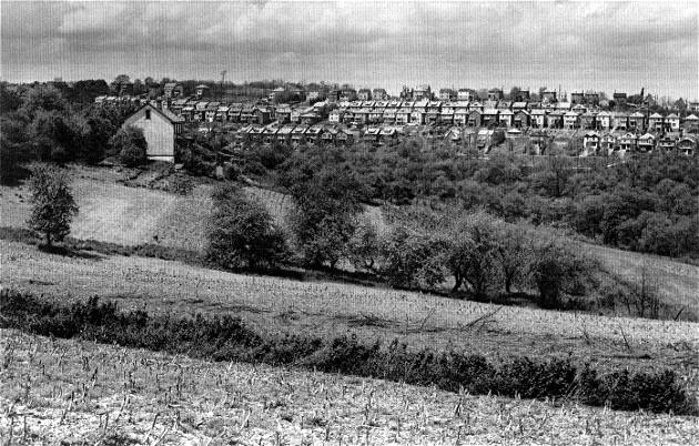
An aerial view of the Brookdale subplot in 1939.
Six homes are standing and many more lots were slated for development.
These are Brookdale homes at 82 Daleview Street
(left) and 1644 Oakridge Street. The Daleview home stood until 1985.
The following may not be
vintage homes or businesses, but they are some of the memorable
Brookline neighborhood attractions that are no longer with us.
39-Brookline
Streetcars
 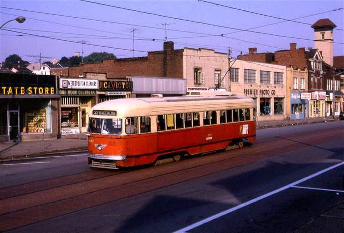
An inbound streetcar passes Birchland Street
as it approaches the Breining Street car stop (left). The trolley loop
is visible in the distance. To the right, an outbound streetcar makes its way
along the 700-block of the
boulevard. Streetcar service in Brookline lasted for sixty-one years, from 1905 through 1966.
<><><><> <><><><>
<><><><> <><><><>
<><><><> <><><><>
The Old Little League
Baseball Fields

The Brookline Little League began playing on the Community Center baseball field in 1952. Shown
here in 1956, the field
stood on a former cornfield. Beyond the fence was the wooded valley between the
Community Center and Brookline
Boulevard. The ravine behind the field was leveled with fill in 1975 during an
expansion of Brookline Park.
 
Another view of the Little League field
in the mid-1960s (left), with the Anderson farmhouse standing atop the hill.
Senior League baseball began in 1961 on the larger field to the
right. These fields were in use until 1981,
when a new baseball/softball complex was constructed in another section of the
park. The land
where the old fields stood became an outdoor basketball court and a swimming
pool.
<><><><> <><><><>
<><><><> <><><><>
<><><><> <><><><>
The Community Center
Swimming Pool

The swimming pool at Brookline Park, shown here in
2001, opened in 1982. The pool was in operation until 2003,
when decommissioned by the city. In 2013, the pool was filled in and replaced with
a DEK Hockey Rink.
<><><><> <><><><>
<><><><> <><><><>
<><><><> <><><><>
Brookline's Original
Cannon

The Brookline Veteran's Memorial was dedicated in May 1935. Located on the Boulevard Triangle, one of
the memorial's
iconic features has been the cannon. The first cannon installed was a 1906 47mm
artillery piece. On October 13, 1942,
this cannon (shown above) was removed and melted down during a World War
II scrap metal drive. It was replaced
in 1946 by the World War I Model 1917 Schneider 155mm howitzer that has stood on
the triangle ever since.
In this photo members of American Legion Post#540 dedicate the cannon before
sending it to the mill.
<><><><> <><><><>
<><><><> <><><><>
<><><><> <><><><>
Old Storefronts
 
During remodeling, old storefront facades sometimes
reappear almost as they were year's ago, giving Brookliners
a brief glimpse into the past. In 2005 it was The Better Half, and in 2017 it was the
Boulevard Men's Shop
<><><><> <><><><>
<><><><> <><><><>
<><><><> <><><><>
The Timberland Avenue
Bridge
 
The Timberland Avenue Bridge stood along Cadet
Street and spanned the West Side Belt Railroad tracks. Shown here in
1918, the rickety wooden bridge was the only access to Saw Mill Run Road for
the Brookline homes in Boggs Place.

The Timberland Avenue Bridge was built in 1909
when upgrades to the railroad line cut off the homes in Boggs Place.
It stood until the late-1920s, when Cadet Street was extended through
the Lang property to Pioneer Avenue.
At the location shown here, the tracks form the boundary between the Brookline
and Bon Air communities.
<><><><> <><><><>
<><><><> <><><><>
<><><><> <><><><>
Coal Mining

Coal mining was the first major enterprise
in the South Hills. The Mount Washington Coal Railroad was extended into the
boundaries of present-day Brookline around 1870. Soon, mine shafts were
scattered all along the West Liberty and
Saw Mill Run corridors. Scenes like this were common along the outskirts of
Brookline until the early-1900s.
The extraction of coal from the Oak Mine underneath the Brookline community continued
until 1941.
 
The Pittsburgh Coal Company installed a power
plant, machine shop and air shaft (left) for the Oak Mine in 1905, located
at the Brookline Junction. The plant and shop were in operation until 1915.
Afterwards, a silo-like airshaft was built
that stood until the 1940s. The Oak Mine pit mouth to the right,
shown in 1931, was located along McNeilly Road.
<><><><> <><><><>
<><><><> <><><><>
<><><><> <><><><>
Home Deliveries Of Coal
 
A horse-drawn wagon, loaded with coal, at the
intersection of Freedom and Merrick Avenue in 1924 (left); Richard Dunn
and Donald Fornear shovel coal along Woodbourne Avenue in 1943. Coal deliveries in Brookline continued into the 1970s.
Loads were dumped along the sidewalk and hauled by bucket to a basement coal chute,
usually near the front porch.
|


