|
The photo above shows the southern portals of the Liberty Tunnels, at the intersection of West Liberty Avenue and Saw Mill Run Boulevard, in 1930. This heavily trafficked intersection was deemed one of the ten deadliest roadways in the City of Pittsburgh by the Bureau of Traffic Planning. This was a time when increasing automobile, street car and pedestrian traffic combined to create a lethal mix, and fatal accidents were becoming a serious problem. From July 6 to July 15, 1930, the Pittsburgh Press ran a series of photos showing the traffic sectors deemed to be the worst in the city. This was the beginning of a city-wide effort to initiate the necessary adjustments to make these roadways safer for all forms of traffic. Below is a Pittsburgh Press article that appeared on July 6, 1930. It was published on the first day of the series, accompanied by a picture of the intersection of Grant Street and the Boulevard of the Allies. The article is followed by photos of the most deadly streets in Pittsburgh. <><><><> <><><><> <><><><> <><><><> <><><><> <><><><> Death Sectors In City Marked By 265 Killings Ten Fatal Stretches Listed As Danger Warning To Drivers Reckless Speeding And Parking Police Redouble Vigilance To Prevent Accidents Over Weekend 1929 (12 months), Killed - 180, Injured - 5100. 1930 (to date), Killed - 97, Injured - 2818. Ten street sectors, named by the Better Traffic Committee and the Bureau of Traffic Planning as the most dangerous in Pittsburgh, were listed Saturday as a warning to reckless drivers, while police increased their vigilance in the hope of reducing the usual weekend list of traffic casualties. Lewis W. McIntyre, engineer of the Bureau of Traffic Planning and Frank L. Duggan, chairman of the Better Traffic Committee, combined in offering suggestions to eliminate casualties on the ten "death stretches." A total of 265 men, women and children have met death in these ten deadly street sectors in seven years. The menace that overhangs the man or woman who must walk across streets where autos speed was emphasized by the fact that 190 of the dead were pedestrians. Three Causes Branded Three general causes that have branded these streets as death traps overruled all others: Speeding. One general recommendation by the experts covered all ten vicinities: Enforcement of existing traffic laws There were specific recommendations applicable to each spot, but the thought that stern enforcement of ordinances already on the books would do much to remedy each local situation was uppermost. The Traffic Safety Observers, a band of 500 citizen volunteers working with the Better Traffic Committee, to report traffic violations, reported real progress in June. Rush Work For Safety The Department of Public Works proceeded with rush plans for strengthening the fences and curbs on the boulevards which run along the edge of the city's precipices. After making use of the $50,000 appropriated by Council this week, the Department of Public Works may find it advisable to ask for an additional $100,000, according to Thomas M. Reed, superintendent of engineering. Bids will be opened July 17 on construction of 4,000 feet of fence on the outer rim of the Boulevard of the Allies in the vicinity of Gist Street, where the death of a woman and her husband when a car crashed the fence a week ago dramatized the city's traffic peril. The work is expected to begin before August 1. New bids have been asked for 1,200 feet of fence on each side of the boulevard along the Forbes Street viaduct. A concrete surface will be laid down on this part of the boulevard in place of the asphalt covering. Street Will Be Closed The thoroughfare will be closed to inbound traffic Monday at 9pm while work proceeds night and day. Twelve inches more will be added to the curb. The work is expected to be done by July 19. The Welsh Construction Company has the $15,000 contract for the surface and curb. Plans of the department include 2,500 feet of fence along Bigelow Boulevard from Twenty-eighth Street to Kirkpatrick Street, and a guard curb and cable fence along the "death curve" in Mansfield Avenue. Still later plans call for fences and curbs along Boggs Avenue and the Mount Washington Boulevard.
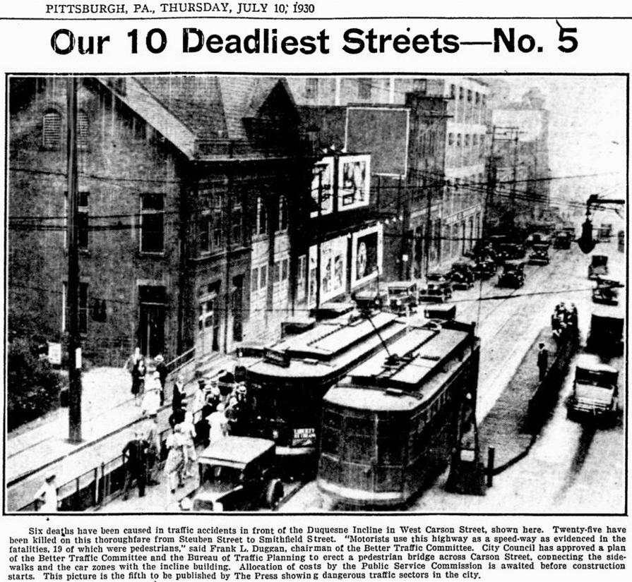
Ten "Death Points" The ten worst traffic stretches, the total of fatalities at each in the seven years covered by the survey and the number of pedestrian fatalities, are: East Carson Street from the Smithfield Street Bridge to Beck's Run Road: 49 dead, 37 pedestrians. The worst point is at the foot of Castle Shannon Incline where nine were killed. Bigelow Boulevard from Seventh Avenue to Craig Street; 34 dead, 16 pedestrians. The worst points are at the Bloomfield Bridge (five dead), Herron Avenue (six dead) and Seventh Avenue (six dead). East Ohio Street from Federal Street to the city line: 34 dead, 19 pedestrian. The worst point is at Walker's Bridge where ten were killed. East Street from Perrysville Avenue to North Avenue: 30 dead, 18 pedestrians. The worst point is at Howard Street with four dead. Where 25 Were Killed West Carson Street from Steuben Street to the Smithfield Street Bridge: 25 dead, 16 pedestrians. The worst points are at the foot of the Duquesne Incline (six dead) and at South Main Street (four dead). Boulevard of the Allies from Grant Street to Craft Avenue: 23 dead, 17 pedestrians. The worst points are at Grant Street (four pedestrians dead) and Twenty-second Street (three pedestrians killed). The experts recommend that this boulevard should have at least six traffic lanes. Although parking is banned, bad parking conditions are found along the boulevard, traffic engineers say. Baum Boulevard from Craig Street to Whitfield Street: 17 dead, 13 pedestrians. The traffic engineers recommend there should be no parking along this stretch 24 hours a day. Fifth Avenue from Fernando Street to Dinwiddie Street: 17 dead, all pedestrians, one of whom was killed by a street car. The worst point is at Dinwiddie Street.
Parking Fatal to 16 The report of the engineers noted that parking, obstructing the view of motorists and pedestrians, was largely the cause of the seventeen deaths. Forbes Street, between Hooper and Van Brahm Streets: 16 dead, 12 pedestrians. The worst points are at Magee Street (four dead) and Marion Street (four dead). Center Avenue from Protectory Place to Addison Street. Fourteen were killed in these six blocks, all pedestrians, one of whom was killed by a street car. West Liberty Avenue from the Liberty Tubes to Capital Avenue: six dead, five pedestrians. The worst points are at Capital Avenue and the Liberty Tubes. The engineers note that this stretch is just becoming serious. 1,150 Die in Crashes From January 1, 1923, to June 1, 1930, a total of 1,152 persons were killed in traffic, according to figures analyzed by the Bureau of Traffic Planning. Of this total, 377 were occupants of autos; 494 were classed as jaywalkers and 281 were pedestrians who had the right of way. For the first five months of 1930, a total of 78 persons were killed, as contrasted to 69 in the same period of 1929. For the first six months of 1930, a total of 112 were killed, as against 77 in the same period of 1929. For the year ended June 1, 1930, a total of 189 were killed, as against 164 for the year ending June 1, 1929.
Motorists Half to Blame McIntyre estimates that 57.1 percent of all fatalities are the fault of motorists. The Traffic Safety Observers called upon their volunteers to dedicate July to reporting violators of "the two most necessary safe driving rules," left side of street car and wrong side of street. One observer made twenty-one reports during June. Drivers who failed to stop for a red light led the list of offenders reported. Reckless driving, speeding and passing a street car on the left were the next in order. Duggan announced the appointment of A.W. Smith, Jr., as chairman of the enforcement sub-committee of the Better Traffic Committee. Smith succeeds McIntyre, who resigned his chairmanship on assuming his duties with the Bureau of Traffic Planning. At an organization meeting Thursday, the committee will again consider the abolition of parking downtown and a proposal that the city own and operate two tow trucks to remove illegally parked cars. Below are Photos of the other Eight Deadliest Streets in Pittsburgh - 1930 Click on images for a larger view |