|
Saw Mill Run originates in Bethel Park and flows north for 9.3 miles before entering the Ohio River about a mile south of the Point in downtown Pittsburgh. The watershed of Saw Mill Run covers 12,343 acres, or about nineteen square miles. The main stream travels along Route 88 to Route 51 in Overbrook, where it meets with Weyman Run, which flows along Clairton Boulevard from Brentwood, with a subsidiary branch running along Provost Road from Baldwin. The enlarged Saw Mill Run then continues northward along Route 51 to the West End. Many other tributaries feed into Saw Mill Run, including Little Saw Mill Run, which runs through the Banksville Road corridor until it intersects the main stream near the Fort Pitt Tunnels.
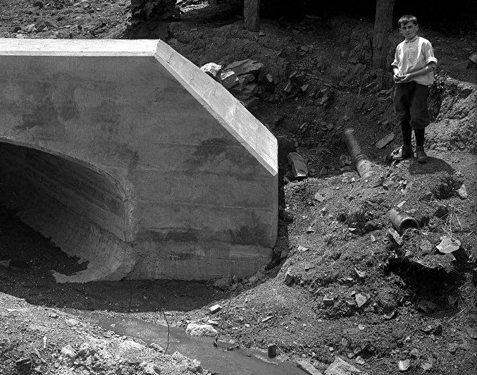
Years Of Neglect And Efforts At Remediation Like many secondary waterways and tributaries bisecting the growing city of Pittsburgh, Saw Mill Run became increasingly polluted with sewer runoff, a problem that grew worse with each passing year. In 1914, public sewer lines and individual residential and commercial sewage was still being discharged directly into the stream. This sewage gathered along the banks of the stream and was washed away during rainy periods. Another problem was the discharge of water from abandoned coal mines along the corridor, which gave the water and stones an orange color. Litter and other assorted items of discarded garbage were also problematic, and for the most part, but the mid-20th century Saw Mill Run was considered a dead zone for acquatic life and a filthy, diseased waterway.
In 1968, the abundant sewage in the stream caused one Pittsburgh Press reporter to refer to the stream as a "source of nauseating odors" and noted how it was "infested with foot-long rats." These problems were not properly addressed until the 1980s. Despite ongoing efforts at stream remediation, water samples taken from the stream in 2000 determined that high concentrations of fecal coliform were still present, a water pollution problem that continues to plague many streams in the Pittsburgh area. Photos of Saw Mill Run
Seasonal Flooding Seasonal flooding is another problem associated with Saw Mill Run. Many homes and businesses located along the low-lying areas near the waterway were the victim of frequent flooding. In the late 1990s many structures along the flood plain were demolished. Dredging and flood control measures by the Army Corps of Engineers have somewhat eased the problem. However, the prospect of flooding will always exist and a strong rainstorm can still bring the water to dangerous levels, often overflowing onto portions of Route 51 between Overbrook and the West End. The year 2018 was a record year for precipitation and also a record year for flooding, with some of the worst recorded flooding all along the basin.
Why Is It Called Saw Mill Run? The creek got its name back in 1759, when a water-powered saw mill was erected at the mouth of the waterway, at the Ohio River. The mill supplied lumber for General John Stanwix and the construction of Fort Pitt. The lumber was floated upstream to the point and cut to size on site.
The saw mill at Saw Mill Run was eventually abandoned and replaced with a Salt Works around 1820. Extracted from flowing wells and refined in the mill, the production of salt was big business. From a modest output of fifteen barrels a day at the start, by the mid-1850s the Union Salt Works could produce up to 300 barrels a day. The Salt Works were in operation at the mouth of Saw Mill Run until approximately 1860.
Saw Mill Run has also become synonymous with the roadway called Saw Mill Run Boulevard, also known as Route 51 or Clairton Boulevard. The photo below shows the West End Interchange, the busy intersection of Route 51, Carson Street, the Steubenville Pike and the West End Bridge, where the colonial saw mill and old salt works shown above once stood.
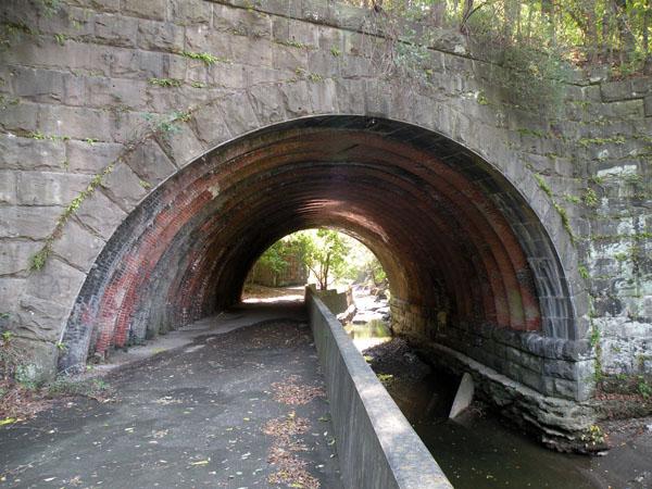
The Seldom Seen Arch Despite the problems with pollution and flooding, and the development along the course of Saw Mill Run, the creek's landscape also contains some wonderful scenic architecture. The Seldom Seen Arch, a decorative stone arch bridge along Saw Mill Run Boulevard near Woodruff Street, is one of these locations. Built in 1903 as part of the Wabash Pittsburgh Terminal Railway, the Seldom Seen Arch is on the list of Pittsburgh History and Landmarks Foundation Historic Landmarks.
A sign near the arch reads: "Beechview-Seldom Seen Greenway - Est. by the City of Pittsburgh July 15, 1985 - Dedicated to the memory of Edward E. Smuts, whose vision and enthusiasm inspired the Greenway Program to preserve Pittsburgh's wooded hillsides. Twenty-two acres of this greenway given as a living memorial by the Western Pennsylvania Conservancy in tribute to Mr. Smuts." It is interesting to note that until the early 1970s there were still several residences located in the wooded greenway. These homes used the small roadway through the Seldom Seen Arch, and followed a lane that ran through the woods, to get out of their tiny enclave. The path of the lane is still open and it leads back to a creek crossing where there was once a small bridge. Most of the homes were located on the opposite side of the creek.
Life has also returned to the creek. Fish, birds and small reptiles and amphibians now call the creek home, not just along the Seldom Seen greenway, but all along the Saw Mill Run Corridor. This improvement is an ongoing process, with several major upcoming initiatives as part of an integrated watershed management plan.
|